Synopsis:
Unsettled times will continue right into the weekend as several areas of low pressure ride along the jet stream. It won’t be raining all the time, but the grey skies will win out. Showers will be spotty today. The majority of Saturday will be dry. If we’re lucky skies may brighten for a time during the morning. Another round of steadier and heavier rain is likely on Sunday.
A change in the weather pattern will occur by early next week with high pressure dominating. This will result in sunny skies.
There has been chatter about an March storm. All of the computer models do have a storm on the map anywhere between March 1st through March 5th. The placement and strength of this system is all over the place as you would expect a week out. Please keep it here for further updates.
Stay tuned
Today:
Cloudy with scattered showers. Highs in the lower 40s in the City, the 30s inland. East winds at 5-10mph.
Tonight:
Early spotty showers, otherwise mainly cloudy. Lows around 40º in the City, the 30s inland. South winds becoming West at 5mph.
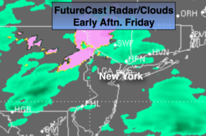
Saturday:
Mostly cloudy. There may be some brightening of the skies during the morning. Chance of showers in the afternoon. Highs in the mid 50s.
Sunday:
A steady rain likely for a majority of the time. Highs in the mid 50s.
Monday:
It’ll finally dry out. Partly sunny skies are anticipated with highs in the lower 50s.
Tuesday:
Sunny. Highs in the lower 50s.
Keep it here for a no nonsense, no hype forecast.