Synopsis:
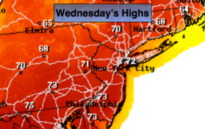
A strong Southeast ridge will dominate our weather through today. This will cause readings to feel like Spring. Clouds and fog with patchy drizzle is possible in spots into this morning, but like yesterday, the sun will return. Today will be the warmest day of the week with readings topping 70º. Coastal areas will be cooler. The record for today at Central Park is 68º set back in 1930. Many new record highs will be set, if not shattered.
Cooler conditions are expected tomorrow as a cool front works in along with an area of weak low pressure. This will cause on and off showers. In fact, well North and West some freezing rain or sleet is possible.
Unsettled times will continue right into the weekend as several areas of low pressure ride along the jet stream. It won’t be raining all the time, but the grey skies will win out.
Stay tuned
Today:
Morning patchy fog, otherwise becoming partly sunny and very warm with record highs. Temperatures will be around 70º. The lower to mid 70s inland. Cooler at the coast. Southwest winds at 8-12mph.
Tonight:
Mostly cloudy with scattered showers. Lows in the lower 40s in the City, the upper 30s inland. Northwest to Northeast winds at 5-10mph.
Thursday:
Mostly cloudy with scattered showers. Much cooler. Highs in the mid 40s. Freezing rain may occur well inland with readings closer to freezing.
Friday:
Mostly cloudy with scattered showers. Highs in the mid 40s.
Saturday:
Mostly cloudy with scattered showers. Highs in the mid 50s.
Sunday:
Mostly cloudy with scattered showers. Highs in the lower 50s.
Keep it here for a no nonsense, no hype forecast.