Synopsis:
A strong Southeast ridge will dominate our weather through Wednesday. This will cause readings to feel like Spring. A warm front will move through this morning. Scattered showers areas of drizzle and fog is expected into this morning. The sun will win the battle during midday first over inland areas. Stubborn clouds may hold at the coast, but some areas will see the sun. Where the sun does shine readings will reach May-like levels. Wednesday will be the warmest day of the week with readings topping 70º. Coastal areas will be cooler. The record for Wednesday at Central Park is 68º set back in 1930. Many new record highs will be set, if not shattered.
Cooler conditions are expected Thursday and Friday as a cool front works through. Scattered showers are likely both days.
Stay tuned
Today:
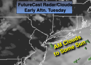
Morning clouds, areas of dense fog drizzle will give way to partly sunny skies. Some Coastal regions will be socked in with clouds all day. Much warmer. Highs near 70º inland. The 60’s in urban areas. Much cooler at the coast. Southwest winds at 5-10mph.
Tonight:
Cloudy. Areas of rain, drizzle and fog. Very mild. Lows in the 50s throughout, the average high temperature is in the mid 40s! Winds becoming Southwest at 5-10mph.
Wednesday:
Partly sunny and very warm. Highs around 70º. Cooler at the coast.
Thursday:
Mostly cloudy with scattered showers. Much cooler. Highs in the mid to upper 40s.
Friday:
Mostly cloudy with scattered showers. Highs in the upper 40s.
Saturday:
Mostly cloudy with scattered showers. Highs in the lower to mid 50s.
Keep it here for a no nonsense, no hype forecast.