Synopsis:
High pressure will move in tonight and Saturday resulting in colder readings. Sun will give way to clouds during the day.
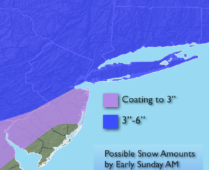
An area of low pressure developing over the Southern Virginia later Saturday will strengthen some as it moves off the Delaware coast late Saturday night. Cold high pressure is slipping off the New England coast at the same time. Snow will rapidly develop Saturday evening and end before dawn Sunday. This will be a quick hitter but the snow may come down moderate to possibly heavy at times for a few hours Saturday Night. The accumulation map is above. Rain or a mix is likely over Southern NJ holding down amounts. The sun will return Sunday with readings well into the 40s.
A strong Southeast ridge will redevelop next week. This will cause readings to once again feel like Spring. Temperatures will feel more like May by Tuesday.
Stay tuned.
Tonight:
Mainly clear and much colder. Lows in the upper 20s to around 30º in the City, near 20º inland. Northwest winds at 10-20mph diminishing late.
Saturday:
Sun will give way to afternoon clouds. Cold. Highs in the mid to upper 30s.
Sunday:
Mostly sunny. Highs in the mid to upper 40s.
Monday:
Morning sun, afternoon clouds. Late day showers. Mild. Highs around 50º.
Tuesday:
Partly sunny and very warm. Highs well into the 60s.
Wednesday:
Partly sunny. Warm. Highs in the mid 60s.
Keep it here for a no nonsense, no hype forecast.