
Synopsis:
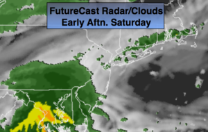
A Southerly flow will develop around the departing high this weekend. This will result in mainly cloudy skies today. Showers will develop this afternoon from Southwest to Northeast (FutureCast Radar above).
On Sunday a deep plume of moisture will move up the Piedmont along a stationary front. The Gulf of Mexico and Atlantic will influence this area of rain. The rain could be heavy at times. One to three inches of rain is possible. The heavy axis of rain looks to setup from the I-95 vicinity to the coast . A Flood Watch has been posted for this area, which is in NJ. NYC and to the North the Flood Watch has not been posted at this time. This will most likely be extended North and East. The rain won’t be nearly as heavy over the distant suburbs. It will be a mild weekend.
High pressure will move in for the beginning of the week with dry, temperate conditions.
There is no threat of snow this upcoming workweek.
Stay tuned.
Today:
Cloudy and mild. Showers developing this afternoon. Highs within a few degrees of 50. South winds at 5mph.
Tonight:
Periods of rain. The rain may become heavy at times late. Patchy fog. Lows in the 40s throughout. South to Northeast winds at 5mph.
Sunday:
Periods of rain. Mild. The rain maybe heavy at times. Highs in the lower to mid 50s.
Monday:
Clouds will give way to sun. Highs in the mid 40s.
Tuesday:
Mostly sunny. Highs in the lower 40s.
Wednesday:
Partly sunny. Mild. Highs in the upper 40s.
Keep it here for a no nonsense, no hype forecast.