Synopsis:
A Southerly flow will develop around the departing high this weekend. This will result in mainly cloudy skies on Saturday. Showers will develop later in the day. On Sunday a deep plume of moisture will move up the Piedmont along a stationary front. The Gulf of Mexico and Atlantic will influence this area of rain. The rain could be heavy at times. One to two inches of rain is possible. It will be a mild weekend.
High pressure will move in for the beginning of the week with dry, temperate conditions.
There is no threat of snow this upcoming workweek.
Stay tuned.
Tonight:
Cloudy. Not as cold as last night. Lows in the upper 30s in the City, near 30º inland. South winds at 5mph.
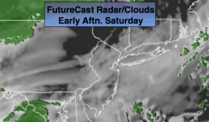
Saturday:
Mostly cloudy. Mild. Late Afternoon or evening showers are possible. Mild. Highs in the lower 50s. South winds at 5mph.
Sunday:
Periods of rain. Mild. The rain maybe heavy at times. Highs in the lower to mid 50s.
Monday:
Clouds will give way to sun. Highs in the mid 40s.
Tuesday:
Mostly sunny. Highs in the lower 40s.
Wednesday:
Partly sunny. Mild. Highs in the upper 40s.
Keep it here for a no nonsense, no hype forecast.