Synopsis:
Low pressure will develop over the area along a cold front causing rain this evening. Well inland snow or a mix is likely with minor accumulation. The precipitation will end toward midnight. Skies will clear and readings will fall below freezing by dawn.
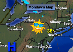
Monday will be sunny and cold as high pressure moves in. The high will move off the coast on Tuesday.
By Wednesday, a similar scenario to Sunday will occur. This time around it maybe slightly colder resulting in a potential of more snow for more areas. This forecast will need to be fine tuned. An accumulation is possible, especially inland and before the changeover.
Dry, tranquil conditions are expected for the end of the week.
Stay tuned.
Tonight:
Rain ending before midnight. Lows in the upper 20s to around freezing. Southeast to Northwest winds at 10-15mph.
Monday:
Mostly sunny and breezy. Highs in the mid to upper 30s. Northwest winds at 15-25mph.
Tuesday:
Mostly sunny. Highs in the upper 30s.
Wednesday:
Snow and rain likely. Highs in the upper 30s to lower 40s.
Thursday:
Mostly sunny. Highs in the mid 30s.
Friday:
Partly sunny. Highs in the lower 30s.
Keep it here for a no nonsense, no hype forecast.