Synopsis:
Today will be the better half of the weekend. It will be cold and sunny with high pressure overhead. An area of moisture over the Southeast will move North on Super Bowl Sunday and at night. There will be weak areas of low pressure one passing to our North the other developing over the tri-state area. This is not a good set up for snow. Snow and rain showers are possible on Sunday any flakes will quickly go over to rain. Well inland some accumulation is possible Sunday night before the precipitation ends. Monday will be sunny and cold.
No major snowstorms are on the map through the upcoming week.
Stay tuned.
Today:
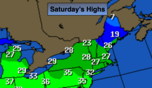
Mostly sunny and cold. Highs around freezing. Southwest winds at 8-12mph.
Tonight:
Increasing clouds. Not as cold as last night. Lows in the upper 20s to around 30º in the City, the teens and 20s inland. Southwest winds at 5-10mph.
Sunday:
Mostly cloudy with a chance of rain showers. Snow showers are likely well inland. Highs near in the upper 30s to mid 40s.
Monday:
Mostly sunny. Highs in the mid 30s.
Tuesday:
Mostly sunny. Highs in the upper 30s.
Wednesday:
Mostly cloudy. Rain is likely. Highs in the upper 40s.
Keep it here for a no nonsense, no hype forecast.