Synopsis:
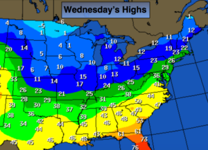
A bitter blast will be with us through the end of the year as the gates are open for Arctic air to spill into the nation as strong high pressure moves in from Canada. The map above depicts the highs for the nation today. Readings will be below freezing through the weekend with overnight lows in the single digits and teens.
Now on to the second story-the snow potential. The models haven’t been in agreement at all as to where and when a low will setup. I’m following the most consistent model the last couple of days-the European. This model has shown a developing storm offshore of the Mid-Atlantic for many runs now. Where the low actually develops and how the upper level low interacts is still a toss up. It looks right now, that it’ll develop too far offshore for any significant snow, I’m including a potential of light snow for Saturday. Again, this is not etched in stone.
Stay tuned.
Today:
Mostly sunny. Very cold. Highs in the mid 20s. Northwest wind at 10-15mph.
Tonight:
Partly cloudy. Frigid. Lows in the lower teens in the City, the single digits inland. West to Northwest wind at 8-12mph. Wind chills below zero.
Thursday:
Mostly sunny. Very cold. Highs in the lower to mid 20s.
Friday:
Mostly sunny. Very cold. Highs in the mid 20s.
Saturday:
Mostly cloudy. A chance of light snow. Highs in the mid 20s.
Sunday:
Partly sunny, windy and bitterly cold. Highs in the upper teens.
Keep it here for a no nonsense, no hype forecast.