Synopsis:
The weekend will be tranquil. The cold will remain as the winds aloft are coming out of Canada, it won’t be as harsh Sunday. A decent amount of sun is expected through the weekend as high pressure dominates.
The beginning of the workweek looks mild as a southwest flow develops ahead of the next cold front.
Looking down the pike. Readings will be seasonal to above average into next weekend. After this time frame it does get interesting. The jet stream will be active and there is a decent amount of cold air just to our North during the days in and around Christmas. Areas of low pressure will ride along the deep trough in the jet stream. How will it all play out?
Stay tuned.
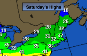
Today:
Partly sunny and breezy. Highs in the mid 30s. West to Northwest winds at 10-20mph.
Tonight:
Partly cloudy. Lows in the upper 20s in the City, the teens inland inland. West to Northwest wind at 5-10mph.
Sunday:
Partly sunny. Highs in the 30s to around 40º.
Monday:
Partly sunny, milder. Highs in the mid 40s.
Tuesday:
Partly sunny, mild. Highs near 50º.
Wednesday:
Partly sunny, windy and colder. Highs near 40º.
Keep it here for a no nonsense, no hype forecast.