Synopsis:
Cold High pressure will be over the region tonight. Under mainly clear skies and nearly calm winds temperatures will plummet.
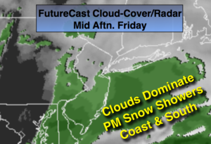
A weak low will develop offshore on Friday. The system will get going just close enough to bring clouds and a period of light snow or snow showers to the the coast, the City and South during the afternoon. A dusting is possible in these areas.
The cold will remain through Saturday as the winds aloft are coming out of Canada. It won’t be as harsh by Sunday A decent amount of sun is expected through the weekend.
The beginning of the workweek looks mild as a southwest flow develops ahead of the next cold front.
Stay tuned.
Tonight:
Clear to partly cloudy an very cold. Lows in the lower 20s in the City, the teens inland and single digits inland. Northwest wind at 5mph.
Friday:
Mainly cloudy with a period of light snow or snow showers at the coast and to the South during the afternoon. Highs near freezing. West winds at 5-10mph.
Saturday:
Mostly sunny. Highs in the mid 30s.
Sunday:
Partly sunny. Highs around 40º.
Monday:
Partly sunny, milder. Highs in the mid 40s.
Tuesday:
Partly sunny, mild. Highs near 50º.
Keep it here for a no nonsense, no hype forecast.