Synopsis:
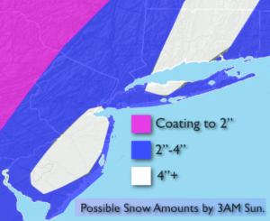
The latest computer guidance has a developing storm off the coast on Saturday. Most of the latest models now have the snow farther West and a bit steadier and heavier. The threat for a light to moderate accumulation of snow has increased for Saturday. The snow may mix with rain over Eastern Long Island. Above are the possible amounts. The heaviest snow looks to be concentrated over parts of central and Southern NJ and Long Island and CT. These amounts will most likely be tweaked as we approach the “event”. The snow should begin around sunrise and continue into Saturday evening.
On Sunday an upper level disturbance will move through with the chance of flurries.
The second unit of energy will come our way Tuesday. At this time, it looks like a decent storm will form. The question is where? If it forms to far North and East we’ll be spared. But, if the storm develops farther South our area could receive “some snow”. There are still many days to watch this one and I’m not writing it off. One thing is for sure the cold is set in stone.
Stay tuned.
Today:
More clouds than sun. Highs in the lower to mid 40s. West winds at 5-10mph.
Tonight:
Cloudy and cold. Lows around freezing in the City, the upper teens and 20s inland. West winds at 5mph.
Saturday:
Snow developing during the morning and continuing throughout the day. Rain may mix with the snow over Eastern Long Island. Highs in the mid 30s.
Sunday:
Clouds and sun. Scattered flurries. Highs in the upper 30s.
Monday:
Sun and clouds. Highs in the upper 30s.
Tuesday:
Mostly cloudy. The potential for a period of snow. Highs in the upper 30s.
Keep it here for a no nonsense, no hype forecast.