Synopsis:
The cold has settled into the region. The jet stream is active and will have units of energy dropping into the trough from time to time forming a storm. The question is, will these areas of low pressure form close enough to give the area a snowfall?
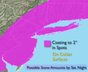
The latest computer guidance has a developing storm off the coast on Saturday. Most of the latest models now have the shield of light snow farther West. The threat for a light accumulation of snow has increased. The snow may mix with and possibly change to rain overnight the Eastern third of Long Island. Above are the possible amounts. These amounts will most likely change as we get closer to the “event”. Cold high pressure, funneling in the cold air, is the ingredient missing to keep this an all light snow event out East.
On Sunday an upper level disturbance will move through with the chance of flurries.
The second unit of energy will come our way Tuesday. At this time, it looks like a decent storm will form. The question is where? If it forms to far North and East we’ll be spared. But, if the storm develops farther South our area could receive “some snow”. There are still many days to watch this one and I’m not writing it off. One thing is for sure the cold is set in stone.
Stay tuned.
Tonight:
Mostly clear, cold. Lows around freezing in the City, the 20s inland. West winds at 5-10mph.
Friday:
Partly sunny. Highs in the lower 40s. West winds at 5-10mph.
Saturday:
Mainly cloudy. A period of light snow is possible. Rain may mix with the snow over Eastern Long Island. Highs in the mid 30s.
Sunday:
Clouds and sun. Scattered flurries. Highs in the upper 30s.
Monday:
Sun and clouds. Highs in the upper 30s.
Tuesday:
Mostly cloudy. The potential for a period of snow. Highs in the upper 30s.
Keep it here for a no nonsense, no hype forecast.