Synopsis:
High pressure will build along the East coast today resulting in cold readings. The return flow around the high will cause temperatures to once again spike into the 5os Tuesday and Wednesday.
An offshore low pressure system will skirt coastal areas late Tuesday night and early Wednesday with showers.
The rollercoaster ride in temperatures will continue as a cold front moves Through Wednesday night. Thanksgiving will be colder under mostly sunny skies with highs only in the 40s.
No major storms are on the map for the rest of the holiday weekend.
Stay tuned.
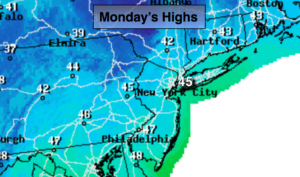
Today:
Mostly sunny, breezy and chilly. Highs in the mid 40s. West winds at 15-25mph.
Tonight:
Mostly clear. Lows around 40º in the City the 20s inland. Winds becoming Southwest at 5mph.
Tuesday:
Mostly sunny, milder. Highs in the mid 50s.
Wednesday:
Early morning showers, otherwise mostly sunny. Highs in the lower 50s.
Thanksgiving:
Partly sunny. Colder. Highs in the mid 40s.
Friday:
Partly sunny. Chilly for Black Friday shoppers. Highs in the mid 40s.
Keep it here for a no nonsense, no hype forecast.