Synopsis:
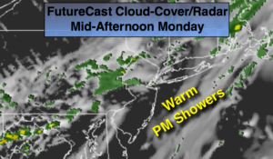
Our rollercoaster ride in temperatures will continue. Well above average readings will be with us today. It’ll be warm with readings well into the 60s ahead of another cold front. Clouds will dominate with times of sun. Showers are possible just about anytime but the best chance is in the afternoon with the passage of the cold front.
Temperatures will return to seasonal averages tonight as cooler air arrives from Canada.
No major storms are in the cards during the week. A few weak systems will skirt by just to our South but it looks like nothing but clouds are in the forecast from these systems. It’ll turn much colder Friday night into Saturday as a significant cold front moves through.
Stay tuned.
Today:
Clouds and some sun. Scattered showers. Warm. Highs well into the 60s. Southwest to Northwest winds at 8-12mph.
Tonight:
Clearing and turning colder. Lows in the mid 40s in the City, the 30s inland. Northwest to North wind at 8-12mph.
Tuesday:
More clouds than sun. Cooler. Highs in the mid 50s.
Wednesday:
Partly sunny and chilly. Highs in the lower 50s.
Thursday:
Partly sunny, seasonal. Highs in the mid 50s.
Friday:
Partly sunny, cool. Highs in the lower 50s.
Keep it here for a no nonsense, no hype forecast.