Synopsis:
For the first time this Fall a stretch of below average temperatures will in the forecast. A strong cold front will move through tonight causing the temperatures to tumble.
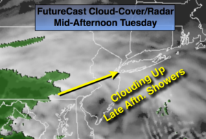
No major storms are in the cards during the week. One weak system will skirt by just to our South later Tuesday and Tuesday night. A bit of light rain is possible later in the day and at night, especially from the City on South.
It’ll turn much colder Friday into Saturday as a significant cold front moves by. A hard freeze is expected throughout the tri-state area Friday night-readings will be in the 20s.
Stay tuned.
Tonight:
Clearing and turning colder. Lows in the mid 40s in the City, the 30s inland. Northwest to North wind at 8-12mph.
Tuesday:
Any morning sunshine will quickly give way to thickening clouds. A bit of light rain is possible later in the day, mainly South of the City. Highs only around 50º. The average high is 57º.
Wednesday:
Partly sunny and chilly. Highs in the lower 50s.
Thursday:
Partly sunny, seasonal. Highs in the mid 50s.
Friday:
Partly sunny, windy and colder. Highs only in the lower 40s.
Saturday:
Mostly sunny, breezy and chilly. Highs only in the lower 40s.
Keep it here for a no nonsense, no hype forecast.