Synopsis:
Our rollercoaster ride in temperatures will continue the next five days. From the 70s Friday, the 50s Saturday, the 60s today and back to near 70º Monday. Warm fronts and cool fronts have been crossing the area every 24-36 hours resulting in the big swings in temperatures.
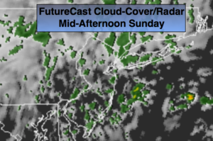
Another warm front will move into and through the area today. On and off showers and drizzle is expected throughout the day. It won’t be a washout. Temperatures should pop into the 60s despite the grey skies.
Monday will be warm again with readings around 70º ahead of another cold front. Showers are likely during the afternoon.
No major storms are in the cards during the week but it looks to turn much cooler and then much colder by Friday.
Stay tuned.
Today:
Cloudy with on and off light rain and drizzle. Mild. Highs in the lower 60s. East to Southeast winds 5-10mph.
Tonight:
Cloudy and mild. Lows just above the average high for the day, which is 58º! Spotty showers. Lows around 60º in the City, the 50s inland. South to Southwest winds at 5-10mph.
Monday:
Clouds and sun. Afternoon showers. Warm. Highs around 70º.
Tuesday:
More clouds than sun. Cooler. Highs in the mid 50s.
Wednesday:
Partly sunny and chilly. Highs around 50º.
Thursday:
Partly sunny, seasonal. Highs in the mid 50s.
Keep it here for a no nonsense, no hype forecast.