Synopsis:
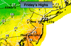
The unseasonably warm weather will continue today as warm air rides North along the East coast ahead of a cold front. This will be considered Indian Summer for many. Indian Summer is defined as a significant warmup after the first frost or freeze has occurred. Many areas have experienced a freeze or frost outside of urban areas. Highs on Friday will be almost fifteen degrees above average. The average high is 58º.
A cold front will approach this afternoon. A spot shower is possible with the passage of the front during the afternoon and evening. Cooler conditions are expected Saturday as high pressure influences our weather from Eastern Canada. The high will move off the coast allowing another warm front to move in Sunday. Showers are possible during the morning but the sun will return and readings will pop into the 60s.
Monday will be warm again with readings topping 70º ahead of another cold front. Showers are likely during the afternoon.
Colder times look to be in our future next week.
Stay tuned.
Today:
Sun and clouds. Warm. Highs in the lower 70s. Spotty afternoon showers. Southwest to Northwest winds at 8-12mph.
Tonight:
Becoming clear and much colder. Lows in the mid 40s in the City, the 30s inland. Northwest to Northeast winds at 10-15mph.
Saturday:
Partly sunny, Cooler. Highs in the mid 50s.
Sunday:
Mostly cloudy with spotty morning showers. Some sun will return by afternoon. Mild. Highs in the mid 60s.
Monday:
Sun to late day showers. Warm. Highs around 70º.
Tuesday:
More clouds than sun. Cooler. Highs in the upper 50s.
Keep it here for a no nonsense, no hype forecast.