
Synopsis:
At least some areas will receive significant rainfall today into Wednesday morning. The ingredients are available: 1) a very humid Southerly flow 2) a strong front & 3) a dynamic jet stream. It’ll feel tropical with the periods of rain and downpours today. Winds will be gust between 35-45mph at times today.
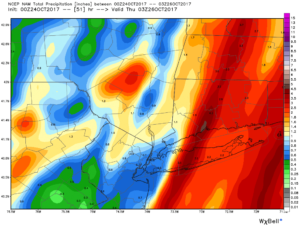
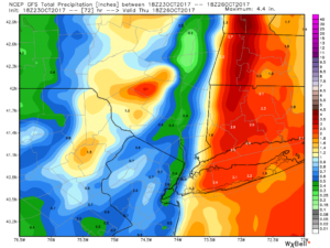
The maps shown are the EXPECTED accumulated rainfall by Wednesday night. The total amounts of rain have decreased with the latest computer guidance. The first map is the NAM model. Yes, it shows 2-4 inches over parts of Long Island and CT. This is possible if the front slows down or stalls for a time. The second map is the GFS which has lighter amounts. Flash Flooding is a possibility with the potential heavy rain. Use caution. It looks like areas to the East of the City will be in the jackpot zone for the heaviest rain while areas to the West won’t see nearly as much rain.
The bottom line is that on and off rain will move in this morning and then push into the City and areas to the East as the day continues. Scattered thunderstorms are expected. Some of the storms may become severe. The rain will continue for a time on Wednesday morning East of the City. The sun will return from West to East as the day goes on.
Cooler and more seasonal conditions are expected mid to late week.
Stay tuned.
Today:
On and off rain. Scattered afternoon thunderstorms. Windy. Locally heavy rain is possible. Balmy. Highs in the lower 70s. Southeast winds at 10-20mph gusts 35-45mph at times.
Tonight:
Rain will end over Western areas but continue East of the City. Lows in the lower 60s in the City, the 50s inland. Southeast to Southwest winds at 5-10mph.
Wednesday:
Morning rain East. The sun will return for many areas. Cooler. Highs in the mid 60s.
Thursday:
Partly sunny. More seasonal. Highs in the upper 50s.
Friday:
Mostly sunny. Highs in the lower to mid 60s.
Saturday:
Partly sunny. Highs in the mid 60s.
Keep it here for a no nonsense, no hype forecast.