Synopsis:
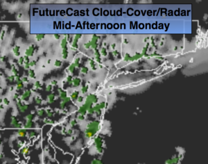
We just got off one of the most beautiful stretches I can remember in October in the tri-state area. The high pressure system both at the surface and aloft that dominated our weather for days will eventually be replaced by low pressure and a cold front. The transition day will be today as the flow turns to the Southeast and allows for moisture at all levels to increase. Clouds will dominate the day with a chance of spotty showers or drizzle. It’ll still be warm with readings nearly ten degree above average. The average high is 62º.
On Tuesday a large trough will deepen over the Eastern one half of the country. At the same time a front will approach from the West. Scattered showers and thunderstorms are in the forecast. The rain may become heavy at times from West to East during the day, at night and during the first part of Wednesday as the front slowly moves off the coast. 1″-3″ of rain is possible through the time frame. The rain is needed as the region has been in a dry spell for a couple of months.
Cooler and more seasonal conditions are expected by late week.
Stay tuned.
Today:
Patchy morning Fog. More sun than clouds. Spotty shower or drizzle. It won’t be a washout. Highs in the lower 70s. Southeast winds at 8-12mph.
Tonight:
Scattered showers and possibly a thunderstorm late. Warm. Lows will be near the average high for the day! Lows in the lower 60s throughout. Southeast winds 8-12mph with higher gusts.
Tuesday:
On and off rain. Scattered afternoon thunderstorms. Windy. Locally heavy rain is possible. Balmy. Highs in the lower 70s.
Wednesday:
Morning rain, possibly heavy East. Some late day sun is possible. Cooler. Highs in the mid 60s.
Thursday:
Partly sunny. More seasonal. Highs in the upper 50s.
Friday:
Sunny. Highs in the lower to mid 60s.
Keep it here for a no nonsense, no hype forecast.