Synopsis:
A large high pressure system will dominate our weather through today. It’ll be warm with readings in the 80s. High clouds from the remnants of Irma may filter out the sun from time to time. A piece of Irma’s remnants will throw clouds our way for Wednesday with a stray shower possible. An upper low will associated with main remnants of Irma will move into the region Thursday & Friday with another chance of stray showers. Nothing substantial is expected whatsoever.
Stay Tuned.
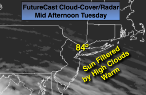
Today:
Sun with high clouds. Warm. Highs in the lower to mid 80s. Northwest to Southwest winds at 5-10mph.
Tonight:
Partly cloudy, not as cool as recent nights. Lows in the mid 60s in the City, the 50s inland. Southwest to West winds at 5mph.
Wednesday:
Mostly cloudy with stray showers. Highs mid to upper 70s.
Thursday:
More clouds than sun. Stray showers. Highs in the upper 70s.
Friday:
Mostly cloudy with stray showers. Highs in the mid to upper 70s.
Saturday:
Partly sunny. Highs in the mid to upper 70s.
Keep it here for a no nonsense, no hype forecast.