Synopsis:
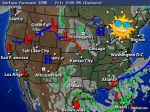
It doesn’t get better than this in August. High pressure will dominate the Northeastern quarter of the country for the several days. This system will result in the first truly cooler airmass of the late Summer season. Temperatures will remain in the 70s through the weekend with mainly sunny skies. Overnight lows will be quite chilly, especially inland. A September preview for sure!
Hurricane Harvey continues to strengthen and will make landfall along the Texas coast late tonight or Saturday as a category 3 storm.. The hurricane will affect the Texas coast with historic, life threatening flooding rains today into next week.
A tropical wave over Florida will move out into the Western Atlantic this weekend and then move Northeast. Many of the computer models have this system strengthening into a tropical storm. Will it come close enough to affect our weather later Tuesday or Wednesday? Right now, the thought is, it stays offshore, but the trend has been farther North and West.
Stay Tuned.
Today:
Mostly sunny. Highs in the upper 70s. North/Northwest winds at 5-10mph.
Tonight:
Clear and cool Lows in the lower 60s in the City, near 50º inland. North wind less than 5mph.
Saturday:
Sunny and pleasant. Highs in the mid to upper 70s.
Sunday:
Sunny. Highs in the mid 70s.
Monday:
Mostly sunny. Highs in the mid 70s.
Tuesday:
Partly sunny. Highs in the mid 70s.
Keep it here for a no nonsense, no hype forecast.