Synopsis:
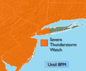
***Severe Thunderstorm Watch is in effect until 8PM for much the entire tri-state area with the exception of Suffolk county Long Island. What this means is that conditions are ripe for the formation of severe storms. Severe thunderstorms contain winds in excess of 57mph and or 1″ hail. Please keep an eye to the sky for threatening weather.***
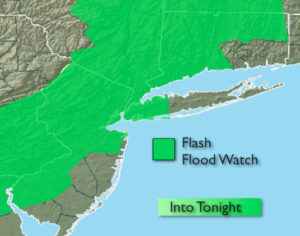
A strong front will be working East today. At the same time a tropical airmass will be in place. This will set the stage for possible severe thunderstorms and flash flooding later today and this evening. A Flash Flood Watch has been posted for much of the tri-state area including NYC. 1″-3″ of rain is a possibility. Obviously, with any storm, frequent cloud to ground lightning and heavy rain is possible.
Tuesday will be much less humid under partly sunny skies. The weather will be picture perfect mid-week.
Stay tuned.
Today:
Hazy, warm and humid. Becoming windy. Late afternoon and evening storms are likely. Damaging winds and heavy rain is possible in spots. Highs in the mid 80s. South/Southwest winds at 15-25mph with gusts over 30mph.
Tonight:
Showers and thunderstorms. Some severe during the evening. Lows in the 60s. West/Southwest winds at 5-10mph.
Tuesday:
Becoming partly sunny and much less humid. Highs in the mid 80s.
Wednesday:
Mostly sunny. Highs in the lower 80s.
Thursday:
Mostly sunny. Highs in the lower 80s.
Friday:
Sun and clouds. Scattered storms. Humid. Highs in the mid 80s.
Keep it here for a no nonsense, no hype forecast.