Synopsis:
The front that gave parts of the area severe storms and flooding rains on Monday will move offshore tonight. Leftover showers and storms will end later this evening.
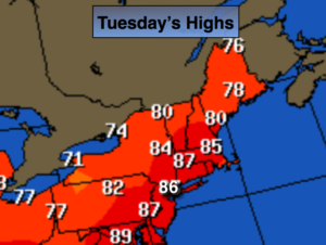
Tuesday will be much less humid under partly sunny skies. Temperatures will be warm.
The weather will cooperate Wednesday and Thursday as weak high pressure moves in. It’ll be comfortable with a mix of sun and clouds.
Humidity and the threat of storms returns Friday.
Stay tuned.
Tonight:
Showers and thunderstorms will move offshore later this evening. Becoming partly cloudy late. Lows in the 60s. West/Southwest winds at 5-10mph.
Tuesday:
Partly sunny and much less humid. Highs in the mid 80s. West/Southwest winds at 10-20mph.
Wednesday:
Sun and clouds. Isolated PM showers are possible. Many areas will remain rain-free. Highs in the lower 80s.
Thursday:
Partly sunny. Highs in the lower 80s.
Friday:
Sun and clouds. Scattered storms. Humid. Highs in the mid 80s.
Saturday:
Sun and clouds. Scattered storms. Humid. Highs in the mid 80s.
Keep it here for a no nonsense, no hype forecast.