Synopsis:
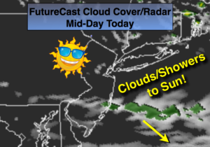
The first weekend of June will be fairly decent. It’ll be bookended by a shower threat but the majority of the time will be dry. This morning will feature a rapidly moving area of clouds and showers associated with a weak trough of low pressure. If you have rain this morning it will only last a few of hours. All areas will experience sunshine and seasonal readings by mid-day and afternoon. It’ll be a gem.
Sunday will start off with some sun but scattered showers and thunderstorms will work in by mid-afternoon as an area of low pressure begins to affect the region from the Great Lakes. The forecast for Sunday is more optimistic.
Unsettled times will be with us for the beginning of the workweek.
Stay tuned.
Today:
Morning clouds and scattered showers. Areas well North of the City will be dry. Becoming mostly sunny and pleasant by afternoon. Highs in the mid 70s. West to Northwest winds at 10-20mph.
Tonight:
Mostly clear. Lows near 60º in the City, the 40s to lower 50s inland. Northwest winds diminishing to 5mph.
Sunday:
Sun to clouds with scattered afternoon showers and thunderstorms. Highs in the mid 70s.
Monday:
Sun and clouds with scattered showers and thunderstorms during the afternoon. The morning looks dry . Highs in the mid 70s.
Tuesday:
Mostly cloudy with scattered showers. Very cool. Highs in the mid 60s.
Wednesday:
Sun and clouds with spotty showers. Cool. Highs in the upper 60s.
Keep it here for a no nonsense, no hype forecast.