Synopsis:
High pressure over the Eastern seaboard will be in control today. A decent amount of sunshine is expected with pleasant readings. The weather will cooperate for the Easter Holiday weekend. A warm front will approach Saturday. A mix of sun and clouds is expected. Spotty showers can’t be ruled out during the afternoon. They’ll be quick movers and much of the day will be dry. Easter Sunday will be June-like with readings reaching 80º or possibly into the 80’s with plenty of sunshine. A strong West to Southwest flow will develop with a Bermuda high to the South and a cool front to the North.
Temperatures will come down in steps early next week.
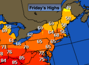
Today:
Partly sunny. Highs in the lower to mid 60s. Northeast to East wind at 5mph.
Tonight:
Mostly clear. Lows in the upper 40s in the City, the upper 30s inland. Light Southwest wind.
Saturday:
Sun and clouds. Spotty afternoon showers. Much of the time will be dry. Highs in the lower 60s.
Easter Sunday:
Partly sunny, breezy and warm. Highs 80º-85º.
Monday:
Partly sunny. Top Ten Day. Highs in the lower 70s.
Tuesday:
Partly sunny. Highs in the lower 60s.
Keep it here for a no nonsense, no hype forecast.