Synopsis:
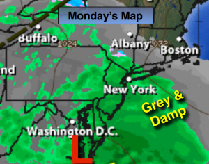
A complex area of low pressure will affect the region today and Tuesday with periods of rain and drizzle. A bit of freezing rain/sleet or wet snow is possible this morning well inland. Readings will continue to be above average for for this time of the year.
January will make it’s presence known by Thursday as a significant cold front works in. There is an outside chance of a bit of light snow on Friday. This remains to be seen as a weak low forms is forecast to form. Where this development occurs will determine if any of the white stuff makes it into our area. Stay Tuned.
Today:
Periods of rain and drizzle. A bit of freezing drizzle or mixed precipitation is possible well inland this morning. Highs in the mid 40s in the City, the 30s well inland. East wind at 5-10mph.
Tonight:
On and off drizzle or light rain. Lows around 40º in the City, the 30s inland. Winds Northeast at 8-12mph..
Tuesday:
Periods of rain and drizzle. Highs in the lower to mid 40s.
Wednesday:
Sun and clouds, mild. Highs in the upper 40s.
Thursday:
Partly sunny and much colder. Highs in the mid 30s.
Friday:
Mostly cloudy with a chance of snow showers. Highs around freezing.
Stay Tuned.
Keep it here for a no nonsense, no hype forecast.