Synopsis:
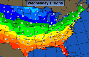
A weak area of low pressure developing well off the Mid-Atlantic coast in conjunction with an upper level trough may result in snow showers overnight with rain/snow showers along the immediate coast (1st map above). A dusting is possible in spots. The Arctic Express will arrive Wednesday Night accompanied by the coldest air of the season so far (2nd map above has the bone chilling facts with highs only in the single digits over the Northern Plains). This cold will be dangerous. Wind chills will be below zero Thursday Night and Friday Morning.
Our next precipitation maker will be Friday Night into the weekend. Frigid high pressure will be moving off the coast at the same time plenty of moisture will be working in from the South and West. The cold air will be hard to dislodge. Snow should break out Friday night and continue into Saturday morning. Amazingly, the warm air will win the battle and the snow will change to rain along the coast and eventually inland. There could be a prolonged period of ice North and West of the City Saturday.
A wild temperature swing will occur this weekend. It’ll be the the tale of two seasons with Winter-like conditions Saturday morning-cold and some snow to Spring-like conditions Sunday morning- temperatures rise well into the 50s!
Tonight:
Mostly cloudy with areas of snow showers (rain/snow showers along the immediate coast). A dusting is possible in spots. Lows in the mid 30s in the city, the mid 20s inland. West to Northwest wind at 5-10mph.
Wednesday:
Partly sunny and breezy. Highs around 40º. Northwest wind at 10-20mph.
Thursday:
The Arctic Express arrives. Partly sunny, windy and very cold. Highs in the mid 20s. Overnight lows in the single digits and teens.
Friday:
Bitterly cold. Partly sunny and windy. Highs in the lower to mid 20s. Wind Chills below zero in the morning.
Saturday:
Snow early, changing to rain along the coast. An accumulation is possible before the changeover. A prolonged period of freezing rain is possible inland before the changeover. Temperatures will rise into the 40s by late day in the City to near 40º inland.
Sunday:
Mostly cloudy, windy and warm with periods of rain. Highs well into the 50s.
Stay Tuned.
Keep it here for a no nonsense, no hype forecast.