Synopsis:
A significant season changing airmass will move into the area by Friday. A cold front will move trough the region and keep our temperatures in the 30s. Plummeting temperatures and gusty winds are anticipated into Saturday under a mix of sun and clouds. Sunday will be more tranquil as the winds abate.
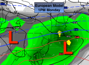
Snow Lovers may have something to cheer about. The latest European model TAKEN VERBATIM (2nd map above) shows a hit of snow Sunday night into Monday morning. The primary low over the Ohio valley will weaken as a secondary low tries to take shape off the NJ coast. This will supply the moisture. High pressure will be in Quebec supplying the cold air. Will the warm air to the South win out or will the cold air be locked in so much of the time the precipitation will be snow? The snow has a good chance of mixing with or changing to rain at the coast and farther to the South during the day on Monday. The event is still 3-4 days away. No way is this etched in stone. Just want you to be aware of the potential. Stay tuned.
Tonight:
Mostly clear, colder. Lows around 30º in the City, the 20s inland. Northwest winds at 15-25mph.
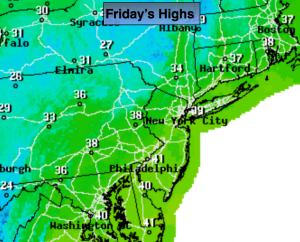
Friday:
Partly cloudy, breezy and much colder than recent days. Highs in the upper 30s. Northwest winds at 15-25mph.
Saturday:
Partly cloudy, breezy and cold. Highs in the mid to upper 30s.
Sunday:
Morning sun, afternoon clouds. Highs around 40º.
Monday:
A chance of snow early with rain or a mix likely at the coast. Highs in the upper 30s.
Tuesday:
Partly sunny. Highs in the mid 40s.
Stay Tuned.
Keep it here for a no nonsense, no hype forecast.