Synopsis:
There will be areas of drizzle this morning as the low pressure system moves out to sea. The sun will make an appearance as the day goes on. Temperatures will be seasonal for this time of the year. A significant season changing front will move into the area by Friday. Plummeting temperatures and gusty winds are anticipated into the weekend. I’m keeping any eye on several pieces to the puzzle for Monday into Tuesday. A rain/wet snow threat is on the table. Stay tuned.
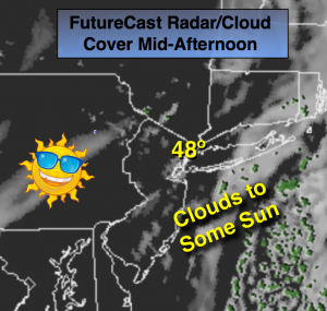
Today:
Areas of drizzle this morning otherwise, becoming partly sunny. Highs in the upper 40s. Northeast to Northwest winds at 5mph.
Tonight:
Partly cloudy. Lows in the upper 30s in the City, the 20s inland. Northwest to West winds at 5mph.
Thursday:
Partly sunny. Highs in the mid 40s.
Friday:
Partly cloudy, windy and much colder. Highs in the 30s.
Saturday:
Partly cloudy, breezy and cold. Highs in the mid 30s.
Sunday:
Sunny and not as harsh. Highs in the lower 40s.
Stay Tuned.
Keep it here for a no nonsense, no hype forecast.