Synopsis:
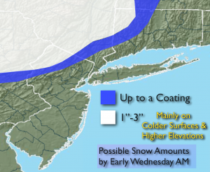
A low pressure system will affect the area tonight into Wednesday. Like the last event it will most likely be cold enough well inland for some wet snow and sleet. Rain and wet Snow (well Inland) will overspread the area this evening. A coating to 3″ of snow is possible over the higher elevations Northwestern NJ and lower NY State by morning. Rain is expected elsewhere. Light rain and drizzle is likely Wednesday morning as the low move out to sea. Late day sun is possible. A significant season changing front will move into the area by Friday. Plummeting temperatures and gusty winds are anticipated into the weekend. I’m keeping any eye on several pieces to the puzzle for Monday into Tuesday. A rain/wet snow threat is on the table. Stay tuned.
Tonight:
Rain, except wet snow well North and West in the higher elevations. Sleet is also a possibility in the colder regions. Lows in the upper 30s in the City, near freezing inland. Northeast winds 8-12mph.
Wednesday:
Mostly cloudy with light rain or drizzle. Late day sun is possible. Highs in the upper 40s. Northeast to Northwest winds at 5mph.
Thursday:
Partly sunny. Highs in the mid 40s.
Friday:
Partly cloudy, windy and much colder. Highs in the 30s.
Saturday:
Partly cloudy, breezy and cold. Highs in the mid 30s.
Sunday:
Sunny and not as harsh. Highs in the lower 40s.
Stay Tuned.
Keep it here for a no nonsense, no hype forecast.