Synopsis:
High pressure over the central part of the country combined with strong low pressure in Eastern Canada will keep the winds busy through today. By Sunday, the high will move over the region bringing and end to the brisk conditions. It will be dry and more seasonal for this time of the year with a mix of sun and clouds. A weak disturbance passing through the region Sunday night and early Monday morning will most likely result in a period of light snow for the region. It doesn’t look like much, but a coating is quite possible in colder areas. Looking down the pike my eyes are on a low pressure system that will affect the area later Tuesday. Cold high pressure wants to hang on over the Northeast but the warm Southerly flow aloft will most likely prevail. The other issue, the some computer guidance suggests the the bulk of the precipitation slides to the South and off the coast. The chances of any snow are minimal at this time. With a mix to rain quite possible inland. A significant season changing front will move into the area late week. Plummeting temperatures and high winds are anticipated. Stay tuned.
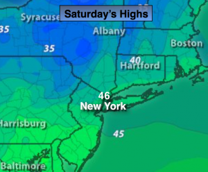
Today:
Partly sunny, breezy and seasonal. Highs in the mid 40s. Northwest winds at 15-25mph with gusts to 30mph.
Tonight:
Mostly clear and colder. Lows in the mid 30s in the City, the mid 20s inland. Northwest wind at 10-20mph and diminishing.
Sunday:
Sun will give way to afternoon clouds. cool. Highs in the mid 40s.
Monday:
A few showers of rain or snow early, otherwise partly sunny. Highs in the mid to upper 40s.
Tuesday:
Morning sun will give way to clouds. A chance of rain possibly mixed with snow and sleet for a time inland later in the day. Highs in the mid 40s.
Wednesday:
Mostly cloudy with light rain possible. Highs in the mid 40s.
Stay Tuned.
Keep it here for a no nonsense, no hype forecast.