Synopsis:
Our rollercoaster ride in temperatures continues. Thursday’s highs reached into the 70s in most areas. A cold front moved through the region and will bring our temperatures down at least ten to fifteen degrees from yesterday. Cool high pressure will move in for the weekend. Days will be bright and chilly and nights will be colder than we’ve experienced.
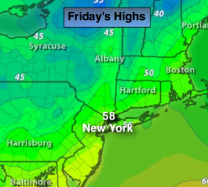
Today:
Mostly sunny, more seasonal with highs in the upper 50s to around 60º. Breezy. Northwest wind at 15-25mph.
Tonight:
Mostly clear with diminishing winds. Colder than recent nights. Lows in the lower 40s in the City, near freezing inland. Northwest wind at 5-10mph.
Saturday:
Partly sunny. Highs in the mid 50s.
Sunday:
Partly sunny, with readings in the mid 50s.
Monday:
Partly sunny. Highs 50º-55º.
Tuesday:
Sunny with highs in the upper 50s.
Stay Tuned.
Keep it here for a no nonsense, no hype forecast.