Synopsis:
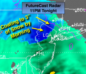
A low pressure system will affect the area later today into Wednesday. Like the last event it will most likely be cold enough well inland for some wet snow. Any sun will give way to thickening clouds today with light rain developing toward sunset. Inland the precipitation will be wet snow (FutureCast radar above snows the areas of blue). A coating to 3″ of snow is possible over the higher elevations Northwestern NJ and lower NY State. Rain is expected elsewhere. Light rain and drizzle is likely Wednesday morning as the low move out to sea. Late day sun is possible. A significant season changing front will move into the area by Friday. Plummeting temperatures and high winds are anticipated into next weekend. Stay tuned.
Today:
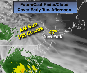
Morning sun will give way to clouds. Rain will develop toward sunset with wet snow well inland. Highs in the mid 40s. North to East wind at 5-10mph.
Tonight:
Rain, except wet snow well North and West in the higher elevations. Freezing rain and drizzle is also a possibility in the colder regions. Lows in the upper 30s in the City, near freezing inland. East winds 8-12mph.
Wednesday:
Mostly cloudy with light rain or drizzle. Late day sun is possible. Highs in the mid 40s.
Thursday:
Partly sunny. Highs in the upper 40s.
Friday:
Partly cloudy, windy and much colder. Highs in the 30s.
Saturday:
Partly cloudy, breezy and cold. Highs in the mid 30s.
Stay Tuned.
Keep it here for a no nonsense, no hype forecast.