Synopsis:
Thursday will be dominated by clouds as moisture builds from the South as high pressure slips into the Western Atlantic. Spotty showers are possible later in the day. The majority of the day will be dry.
A cool front will approach Friday. More clouds than sun is expected. It’ll be humid and warmer. Scattered showers and storms are possible later in the day and the evening.
The beginning of the Memorial Day weekend may start off with showers with an upper level trough moving through on Saturday.
At this time Sunday and Memorial Day should be dry and bright with moderating temperatures as high pressure builds over the region. All of the computer models are now in unison with this scenario! This is good news. Hopefully, it’s 2 out of 3 for the Holiday weekend!
Stay tuned.
Keep it here for a no hype, no nonsense forecast.
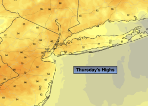
Thursday:
Mostly cloudy with spotty late afternoon showers possible. Highs in the mid to upper 60s. Southeast winds at 5-10mph.
Tonight:
Mostly cloudy with areas of patchy drizzle possible. Milder than recent nights. Lows in the mid 60s in urban areas, the upper 50s to lower 60s inland. Southeast winds at 5mph.
Friday:
Mostly cloudy with showers and thunderstorms likely later in the afternoon and evening. The majority of the day will be dry. Warm and humid. Highs in the mid to upper 70s.
Saturday:
Mostly cloudy. Chance of showers. Highs in the mid 70s.
Sunday:
Partly sunny. Highs in the upper 70s.
Memorial Day:
Sunny. Warm. Highs in the lower 80s.
Catch me on the Fox Weather Stream from 10am-1pm Thursday. Find us on Tubi, Roku TV and YouTube TV and as always the Fox Weather App. It’s Free!