Synopsis:
Extensive cold high pressure with a flow out of Canada will result in below average temperatures today despite the abundant sunshine.
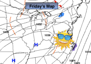
During the weekend the large dome of high pressure will slip off the coast resulting in a Southwest flow. This will allow the mercury to once again rise above the average high of 43º.
The beginning of the week will continue with our Spring preview. Monday will be bright. Showers are expected Tuesday with an approaching front.
Stay Tuned.
Keep it here for a no nonsense, no hype forecast.
Today:
Sunny. Chilly. Highs in the mid 30s. Northwest winds at 5-10mph.
Tonight:
Clear and cold. Lows in the upper 20s in the City, 10º-20º inland. West to Southwest winds at 5-10mph.
Saturday:
Sunny. Milder. Highs in the mid to upper 40s.
Sunday:
Sunny. Highs around 50º.
Monday:
Partly sunny. Mild. Highs in the lower to mid 50s.
Tuesday:
Mostly cloudy with scattered showers. Highs around 50º.