Synopsis:
Strengthening high pressure will dominate the Eastern one third of the nation through the rest of the week. The result will be plenty of sunshine and cooler than average readings through Thursday as a pool of cool air works in from Eastern Canada. The average high temperature is 75º. There will be in a nip in the air during the overnights. A significant warm up is expected into the weekend-the last weekend of Summer.
Hurricane Humberto will remain well off the US coast and continue into the far Atlantic. Bermuda will feel the hurricane’s affects tonight and Thursday.
Stay Tuned.
Keep it here for a no nonsense, no hype forecast.
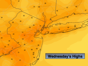
Today:
Sunny, breezy and cool. Highs in the 60s to around 70º. Northeast winds at 10-15mph.
Tonight:
Clear and chilly. Lows in the lower 50s in urban areas, the upper 30s & 40s inland. Northeast winds at 5-10mph.
Thursday:
Sunny. Highs around 70º.
Friday:
Sunny, milder. Highs in the mid to upper 70s.
Saturday:
Sunny. Warm. Highs in the lower to mid 80s.
Sunday:
Sunny. Warm. Highs in the mid 80s.